|
At the time of writing the 2024 thunderstorm season in N. Ireland has been the absolute worst I've ever experienced in my life. May began with great encouragement with several warm season storm set-ups which took me to Donegal then back to my home area, the latter producing the best storm of the year near Ballyronan Marina and just when things were ramping up with high standards everything declined rapidly. The jet stream became displaced far to our south bringing hot humid weather, severe thunderstorms and supercells across Europe while Ireland was plunged into a cooler regime with cloudy high pressure then later fronts with no instability, our weather was almost daily subjected to cooler NWly flows bringing stable overcast conditions and it seemed we became locked into this pattern for an eternity.
The result was a substantial thunder drought the likes of which I had never experienced before which left myself and my chaser friends feeling bitter and frustrated, especially after the best storm year of our lives during 2023, the contrast between the two years was night and day, it was difficult to believe it was the same country. Don't get me wrong, this Summer hasn't been terrible, to be honest it has been fairly dry, I've seen a lot of worse Summers than this with 2008 being a recent example, in fact, we are lucky we haven't been getting non stop rain with flooding and strong winds, in that regard we have been lucky. The biggest complaint this season has been the suppressed temperatures, reduced sunny days and of course the complete lack of proper convective action.
This changed around mid July but not in a dramatic way, normally at this time of year we would be benefiting from warm humid SWly flows with CAPE values between 1000 and 1800 j/kg but this year only a few days were showing 20-200 CAPE which do be honest is similar to an unstable Winter's day, these values were embarrassing to say the least. However despite all the doom and gloom I'm still an optimist and I look for something in every atmospheric opportunity. If you are truly interested in convective weather in UK and Ireland then you will be fully aware that surprise photogenic and even severe events can happen during marginal days and this is why I always pay attention to the sky even if things don't look great as nature as a way of surprising us.
On July 14th one of my chaser mates Colleen Webb was driving through Dunloy when she glanced at the clouds in the distance in the direction of the Sperrins and was shocked to witness a funnel cloud. Initially surprised and frozen by the funnel she went into action grabbing her DSLR and long lens and captured a series of impressive images of a rather substantial funnel which was large and photogenic. However what made this encounter all the more impressive was that Colleen was able to observe it for approximately 30 min's!, this was a shock to everyone however the basic atmospheric parameters, once models were consulted, hinted at the prospect in hindsight with weak convection in a slack flow with surface convergence.
This funnel generated much interest and as a result our convective forecaster Owain Rice took a look at the models and posted an outlook with the prospect of more funnel clouds the following day on July 15th. The models showed 50-125 j/kg of CAPE with 3CAPE in the lower 3km of the atmosphere, tops were warm however there were zones of colder air between -10c and -20c, borderline and likely too mild for any thunder however enough to aid with convection. Warm temperatures were expected with generous solar heating with OK dew points and the flow was completely slack once again. Of greater interest was a well defined convergence zone extending across NW Ulster into NW Ireland from Donegal across the Sperrins and northern portion of the country. GFS and AROME indicated scattered showers could break out so it looked like there could be a chance of another funnel, I chatted with Owain that night and he insisted that the best parameters looked to be over Co. Donegal.
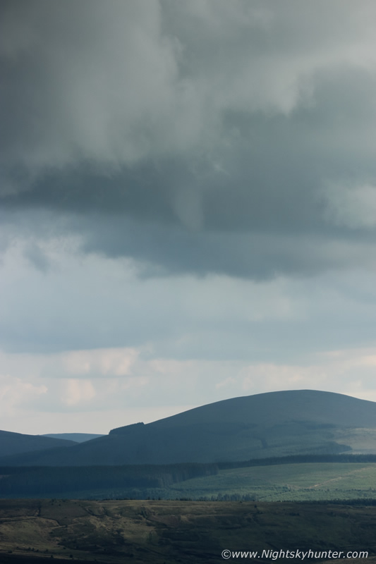
I intended on going funnel hunting however I wasn't planning on going that far on this day but instead reckoned the Sperrins would be a good candidate, Owain and I both agreed that the Dungiven area would be a good place to observe with Benbradagh mountain offering the best view of the area. The next day began foggy in Cookstown but by early afternoon the sun burned through and the sky cleared and it became very warm and quite humid. Plans were made with Colleen Webb and Nigel McFarland to spend the afternoon and evening hunting for funnels. I packed supplies then my dog Rhua and I hit the road, I honestly had a very good feeling and was confident of catching a funnel however I suspected it would likely be something small and not very photogenic, even if we didn't see a funnel it was a good excuse to catch up since we have only got chasing together a couple of times the entire season.
While approaching Tobermore I was delighted to see a row of well developed Cumulus and Towering Cumulus across the Sperrins in the direction I was heading, it amazed me how rapidly they had formed, the parameters were evolving like clockwork. The towers were definitely not tall enough for sparks however they were very crisp and quite solid in places and that's all that's need for a funnel. Funnels can even form from 'dry' bases under developing convection not associated with any precip at all so you don't need strong cells or thunderstorms, or even showers in some cases. The idea is to get yourself into the area where the best convergence and instability overlap and watch for towers, if you see bases then keep your eyes trained on them all the time with your camera close to hand, if one appears you will need to react fast as many are fleeting with their most photogenic aspect lasting only seconds to minutes so your camera needs to be set to the light available with correct exposure with the appropriate lens attached, speed and preparation are essential.
By the way if you have never seen a good funnel cloud before then you don't know what you are missing. You will never understand the absolute thrill of seeing these until you have seen your first, and after that it becomes an addiction. It's like looking for a needle in a haystack but when you eventually see the needle its unlike anything you have experienced before. The feeling is beyond description, funnels are special and no two ever look the same. Some are small and not very dramatic, others can be scuddy, but the best have well defined form with a smooth profile, they can change shape by the second like a living entity and large funnels can be truly spectacular and often leave a lasting impression on witnesses, some of these can become briefly tornadic if surface contact occurs. I can tell you from my own personal experience that a large in your face funnel can be a life altering experience, in fact, it was my first encounter during July 17th 2007 which completely altered the direction of my life to this very day.
A few tips, you need to understand the synoptic conditions which generate funnel cloud formation, understanding this will help by knowing which days to be looking and where within your country to search. Then a basic understanding of convective clouds is essential, especially Cumulus Congestus (updraught towers) and Cumulonimbus clouds and being able to identify bases associated with these cloud species. Next a good vantage point will greatly increase your chances of success, either a wide open space or elevated location, if you can see bases then you are good. The last tip is complete and utter dedication, you need to be watching the sky for hours and never faltering with your goal, all convective bases must be monitored constantly, even though sky watching in itself is easy the discipline required to get results is not as easy as it first seems.
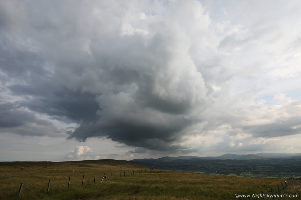
I have digressed, now back to the hunt. As I drove along Glenshane Pass I could see a nice base in the distance under that convection and I honestly thought to myself we might actually have a chance of getting something here at some stage today. It was warm and I was feeling thirsty and I almost pulled into the filling station to get an ice lolly as there was no mad rush to be on location, however I had a strong compulsion to drive on and that every minute counted which was a strange feeling so I trusted my instincts and kept driving. I went through Dungiven then arrived near the summit of Benbradagh. I could see Colleen in a field watching convection with her camera in hand, she yelled across the field that she had just been watching rotation under one of the closer bases. I grabbed my DSLR, attached the 100-400mm lens and walked into the field to meet her, we said a few words, I had only been there a couple of minutes when I glanced to the NW and yelled ''funnel!''.
 |
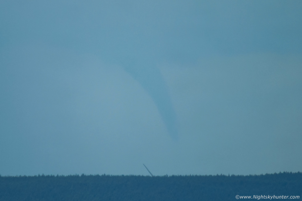
We couldn't believe it, there was a fully developed funnel cloud rite in front of us where there was none a moment ago, there was no warning, it was just there. We got the cameras in action and began shooting while making visual observations of what we were seeing. At first we were in shock by its sudden appearance but then instinct took over and the challenge of getting images consumed us, it was lucky we had our long lenses attached and ready.
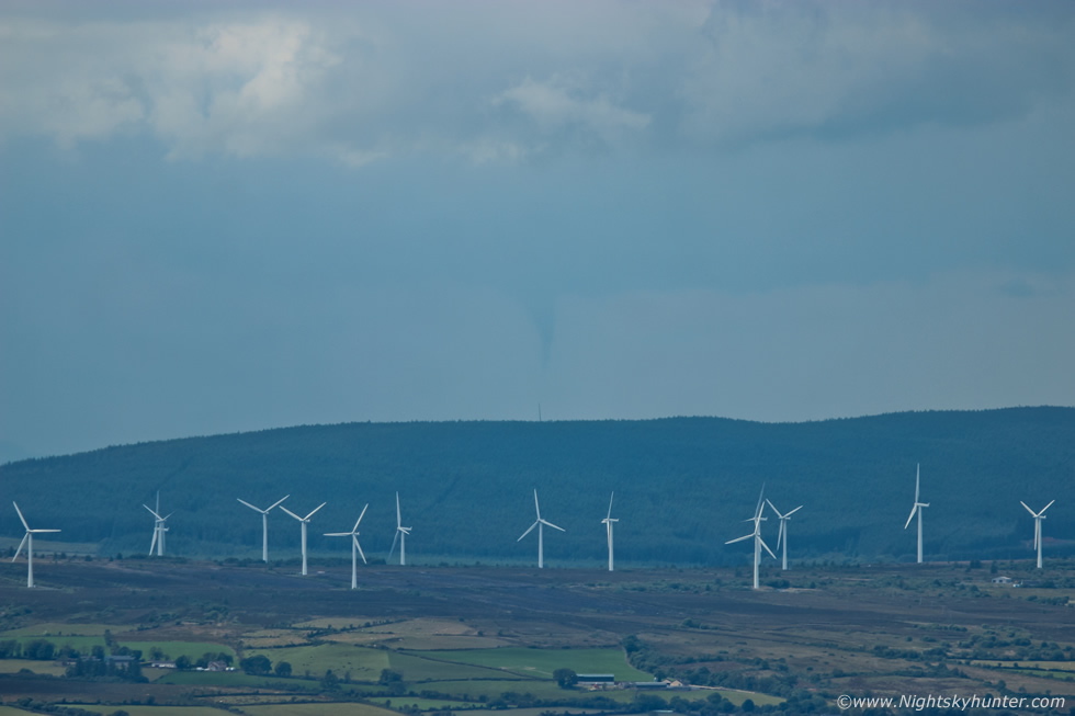
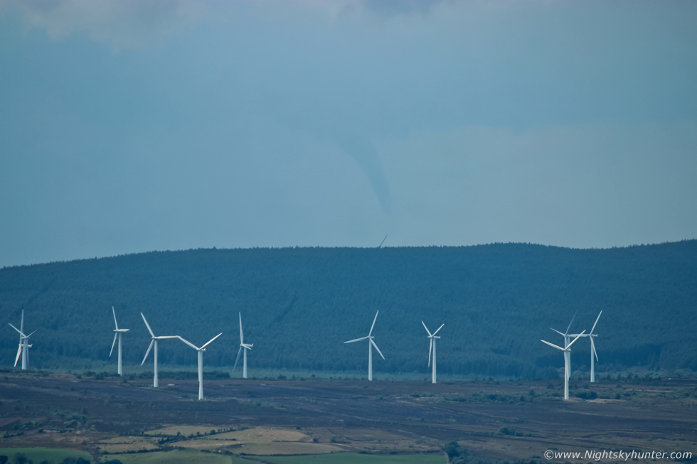
I need to explain what we were up against, the sky was hazy, the funnel looked quite far away, and it looked like it was partially obscured by a curtain of precipitation, in fact, it was likely behind the precip which made shooting it extremely difficult as the scene lacked transparency and contrast, but this was what we were dealt with so we had no choice but to do our best with what we were presented with. This image is 100mm with my old beaten Canon 600D crop sensor DSLR. From our vantage point the funnel was to our NW, beyond a wind turbine farm, beyond the distant hill and on the far side of another turbine farm, you can see one of the blades below the funnel, we didn't know exactly where it was however we suspected it could have been along the west side of Lough Foyle or somewhere over the Foyle basin which was a substantial distance away.
 |
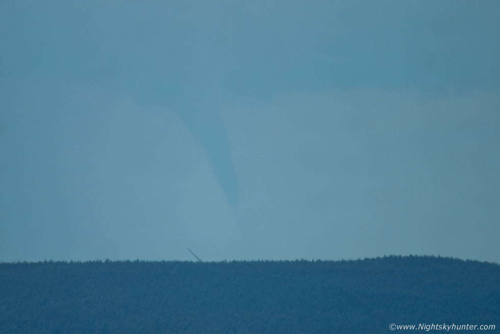
The funnel began to change shape which we could observe in real time with a bend in the lower snout, you can almost make out that wall of haze and precip between us and the vortex. Colleen and I were shooting constantly while yelling with delight.
 |
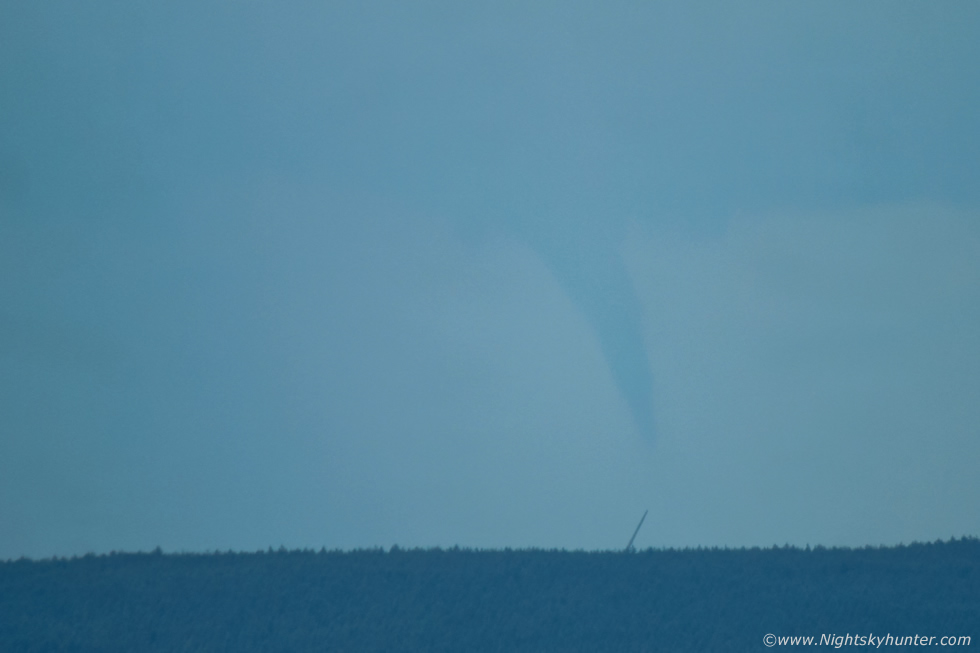
Then it morphed into its most photogenic aspect as a solid stove pipe with an elegant slant forming, it looked like it was alive. I was saying to Colleen ''holy sh*t that's a very substantial funnel''. These were taken at 400mm and cropped, at times it was difficult to see in the viewfinder but once I lifted my head away from the camera and looked it was a striking sight, we both agreed it was more impressive with the naked eye than it was on camera.
 |
We both agreed this was a major, it brought back memories of the July 2007 funnel all over again. Colleen remarked that it could even be a waterspout, this was great thinking and entirely possible, it looked to be over the Foyle area and we couldn't see below it due to the hill, we knew that social media was going to be flooded with images soon as there was no way this funnel was going unnoticed.
 |
400mm
 |
We just looked at each other and thought this actually looks like a tornado, we were both shocked, even though we knew funnels were possible today we didn't think anything of this standard was going to happen, and for it to appear within minutes of my arrival was surreal, talk about timing, good job I didn't stop at the filling station after all.
 |
The funnel began to lift and tilt slightly, this can often be an indication the vortex was going to vanish soon, likely due to cooler outflow wind from the precip core affecting the inflow.
 |
Tilting more then it thinned and we lost it from sight as it vanished as suddenly as it appeared. We had observed it from 14.50 to 15.00 approx for a duration of ten minutes. We where on a high and couldn't believe what we had just seen, I knew it was a substantial funnel which I would rate as the fourth best I've ever witnessed and perhaps the second largest, I just wish we had been closer, but at least we got a record of it. We then calmed down and went online for a look on social media, this had to be on there already as it looked a major event, we were not wrong.
Images were already on social media and it became quickly apparent that the funnel wasn't over the Foyle, it wasn't even over N. Ireland, it was near Letterkenny in Co. Donegal which was approximately 25 miles away as the crow flies from our position. This was astonishing, not only was this the furthermost funnel we had seen but it had to have been massive. The images we saw online confirmed this suspicion, it was captured from Derry/Londonderry and at closer range from Donegal by numerous witnesses on their mobile phones and the images were absolutely spectacular!
We drooled over the images, those who captured it had hit the jack pot, getting a funnel of that size and photogenic quality so well on camera was like winning the elemental lottery, I'm certain some of them didn't know how lucky they were, some people spend their lives hunting this stuff and here it was snapped on mobiles phones with ease, some didn't even know what it was and called them 'peculiar clouds', if only they had known they had come close to a tornado dropping. The funnel was large and substantial and for a while it was suspected to be a landspout tornado however given its height above the surface it was likely not in contact with the ground but we cannot be sure about this with 100% confidence so the jury is still out.
Then just to make this event even more impressive images began to appear showing not one funnel but two funnels at the same time, there was another one from a second base behind the main funnel with both funnels pointing different directions and taking on varying shapes, it was amazing, a true funnel cloud outbreak and quite an historic event for this country, there aren't many images about showing two fully mature funnels at the same time in the same camera frame, it really was a wow moment. When we saw those amazing images it made our images look pathetic in comparison to the point were we didn't want to post them at all, it almost felt embarrassing, we had distance, haze and precip to deal with and the images even had dust spots on them which I had to remove in post, that must have happened when I put on the big lens.
This was a spectacular visual event but a photographic failure, or so it seemed to us. Later Nigel McFarland encouraged us to post the images in public, they may not be the up close trophy images we wanted however they did serve a purpose, they showed the funnel from a different angle and more importantly they are the only images showing this event from 25 miles away so that in itself is of interest and hence why I've decided to document the event on here.
On another note my crop sensor DSLRs will be entering the camera graveyard soon, I have two 600D camera bodies which I've used for years, one of them kicked the bucket last week when the shutter failed including the menu buttons so its now a paper weight on my bookshelf. Now the other 600D is having issues with buttons and scroll wheel not working at all so it will likely stop working anytime. Although this is unfortunate for me I can't be too annoyed, they have both served me well for years capturing all kinds of sky action and have been put through the mill and abused and still delivered so I'm proud of what they achieved, they have captured many funnel clouds so its fitting that my last 600D captured this event so it can go out in a blaze of glory.
Speaking of Nigel, he arrived on location soon after and the three of us spent the rest of the day on the summit watching for more funnels, literally for hours out in the elements and it was a wonderful experience. It was warm and dead calm, not a breath of wind which was strange for this altitude, we stood with cameras close to hand starring at the sky and chatting about funnels and storms while catching rays. There wasn't a sound, it was unreal, so quiet I could hear the pulse beating inside my ears, I never felt so much peace in a long time.
 |
Then after 19.00 capped convection appeared and slowly inched closer, a compact but solid base had formed then another funnel appeared. This one was a short stubby tuba funnel and never made it far down from the base but it still presented a rather smooth shape, this was at 100mm with the Sperrins in background.
 |
100mm portrait
 |
It then vanished but I got the full frame out with 15mm lens for a wide angle view of the scene. One solitary almost stationary capped tower with a compact curved horseshoe base where the funnel had emerged form. After 20.00 we called it a day, we had been watching for over five hours and had bagged two funnels, not a bad days hunting after all and the lesson learned was to never under estimate the potential of mediocre days. A big congratulations to Owain Rice for his exceptionally accurate forecasting once again. Thanks very much for reading.
Martin McKenna